BEFORE THE BULLDOZER
A Nottingham allotment site destined for change
The Bilborough Brook
The Bilborough Brook traverses the site almost centrally, running from north-west to south-east. It enters the allotment site via a large pipe system from beneath Torvill Drive and beyond that the industrial estate on Glaisdale Drive; it exits the allotment site at its confluence with Martin's Pond an the boundary between the two. The source of the Brook is believed to be the parkland area around Strelley Village, but the old maps are quite difficult to interpret. The brook is just visible, but not named, on the 1815-30 OS map and joins the Nottingham Canal; on this map there is an arm off the canal called the Bilborough Cut which appeas to be culverted under the Radford & Ilkeston Railway and heads towards Old Park Farm and Sheppards Wood at Bilborough. On the 1881-89 OS map a stream is mapped in the position of the Bilborough Brook but again its source is shown as the Nottingham Canal. We would appreciate any further information on the source of the Brook - please use the Contact Us form.
The banks of the Brook have a trapezoidal cross-section, possibly 60 cm wide at the top and 20 cm at the base. The Brook is heavily shaded along the entire length by hedgerows and some trees, allowing little vegetation to take hold. There is some herbage on the banks, such as cow parsley, cleavers, great willowherb and stinging nettles. Two bridge structure cross the Brook, the one near Martins Pond is pedestrian only, the one on the main avenue is also used for vehicle access. The water depth is normally shallow, perhaps 6 cm, and is barren of vegetation; during heavy rainfall the level increases up to about 20-30 cm. The base of the Brook is extremely silty, with parts containing rubble and sometimes rubbish. The Brook suffers from occasional pollution, the source of which has never been conclusively determined.
So, the picture is one of a rather dark, narrow stream that is difficult to access; not an easy photographic subject! But here are some shots which maybe give a feel for the Brook and its surroundings:-
 This is a stock image of a spined loach, a European Protected Species which is present at the confluence of Bilborough Brook and Martin's Pond. |  Pink weed growing in the Brook near the main avenue bridge; this is an indicator of poor water quality [29/10/12] |  We know what curiosity did; but this visitor seems to enjoy being beside the Brook [11/12/12] |
|---|---|---|
 Lots of intriguing animal holes along the Brook [13/02/13] |  Question - was this to drain water off the land or take water to it? Suspect it shouldn't be there... [08/02/13] |  Same pipe a year later after heavy rain [13/02/14] |
 Badger prints in the Brook [16/02/14] |  The almost-overgrown footpath near Martin's Pond; the Brook is down the bank to the right [21/05/14] |  An intrepid gardener heading for the previous path at the Brook. In the background, this building was used for many years as the Site Shop. |
 The Brook from the pedestrian bridge near the confluence with Martins Pond [16/08/14] |  Male 3-spined stickleback in his breeding colours by the confluence with Martin's Pond [03/07/15] |
The Bilborough Brook is destined for massive change and complete re-routing but the end result is likely to be much more attractive and biodiverse than it currently is, especially in terms of flora. The area surrounding the Brook is planned as Public Open Space, although access to it and security within it is not yet clear. The area of the Brook will be part of a Sustainable Urban Drainage Scheme (SUDS), including swales to allow run-off of surplus surface water. The brook itself will be re-routed into a more pleasing serpentine shape and is to include a circular basin which is designed to act as a retention basin in the event of heavy rainfall or flooding; confusingly this circular area is also currently designated on the plans as a Play Area...
Here is the current plan which the developers submitted and which was approved on Appeal, subject to certain planning Conditions including mitigation for the presence of the spined loach by minimising disturbance at the confluence of the Brook with Martins Pond. The following rather indistinct map is taken from the Planning Application [it is slightly clearer if you Click on the image]: the original, with its key, can be viewed on p.48 of the full Flood Risk and Drainage Strategy report here:

It is to be hoped that this ambitious plan overcomes some of the problems and concerns regarding site drainage. The nearby residents know only too well that the current drainage system through the Torvill & Dean estate does not cope with heavy rainfall. The Brook itself has a long-term problem with pollution, and it is difficult to understand why - in this technological age - the source of the problem has not been identified and dealt with. Let's hope both these issues are at last corrected as part of the development work. Below are a few photos which indicate the problems (although water is notoriously difficult for the amateur to photograph!):
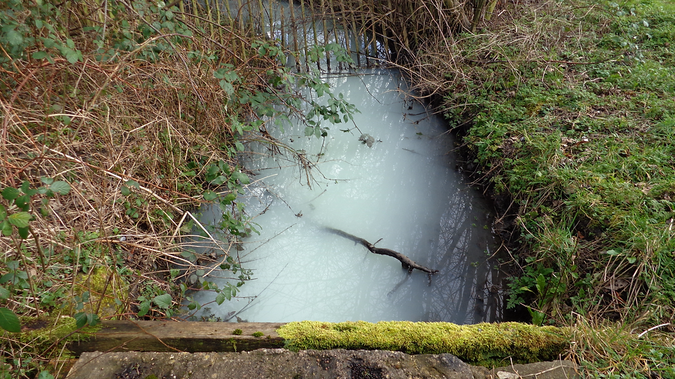
A severe pollution incident in the Bilborough Brook on 16 Feb 2014 after heavy rainfall. This shot is of the confluence of the Brook with Martins Pond.

Plot 160 on the Pondside avenue after heavy rain in Feb 2014.

Plot 85 is on higher ground on the main avenue close to P-Block: but the area still gets waterlogged, as evidenced by the growth of reed-type grasses [Feb 2014]
A severe pollution incident in the Bilborough Brook on 16 Feb 2014 after heavy rainfall. This shot is of the confluence of the Brook with Martins Pond.